Buddhist pilgrims
Annapurna circuit
Nar-Phu Valley Trekking
Nar-Phu Valley Trekking
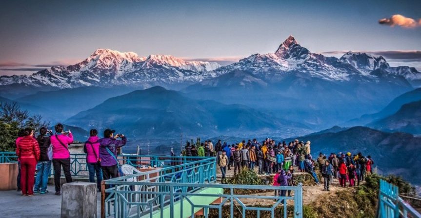
Trekking in Nepal
Trekking in Nepal
Trekking in Nepal

Nar-Phu Valley Trekking
Nar-Phu Valley Trekking
Trekking in Nepal
Trekking in Nepal
Trekking in Nepal
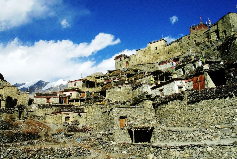
The Nar and Phu valleys are newly opened, spectacular regions of ethnically-Tibetan inhabitants for those of you that think you have trekked it all. This is a trek that combines high peaks and passes, glaciers, remote villages, narrow canyons, lovely forests, amazing rock formations, yaks, gompas and unique Himalayan cultures.
Trekking the standard Annapurna circuit, the bridge leading over the Marshyangdi River to the steep portals of the Nar Phu valley system is easily missed, but although the entrance is narrow and forested, the valley system above opens up to a huge expanse of high snow-peaks, ancient villages and high altitude grazing settlements. Two long days of walking from the border of Tibet, this region was first explored by Tillman in the 1950s. Closed to trekkers until late 2002, very few westerners have explored these virtually untouched villages or climbed the many 7000m peaks surrounding it. We will venture into this remote region of upper Manang, camping along the way at the winter settlement of Nar and Phu, and visit some of the most unvisited and most interesting villages in the Tibetan Buddhist world. Buddhist pilgrims from around Nepal might accompany us up to Phu to visit the renowned Tashi Lhakhang Gompa and receive a blessing from Lama Karma Sonam Rimpoche. Along with spending plenty of time at these colorful and timeless villages, we explore the high alpine valleys above Phu.
Outline Itinerary
Day 01– Arrive at Kathmandu.
Day 02 – Full day guided sightseeing around world heritage sites inside the Kathmandu Valley.
Day 03 – Drive: Kathmandu / Besishar (760m / 5 hrs). Trek to Kuhdi (790m / 3 hrs)
Day 04 – Trek to Bhaunadanda (1310m / 4 hrs)
Day 05 – Trek to Tal (1700m / 6 hrs)
Day 06 – Trek to Chamje (1430m / 5 hrs)
Day 07 – Trek to Bagarchhap (1430m / 6 hrs)
Day 08 – Trek to Koto Qupar (2600m / 6 hrs)
Day 09 – Trek to Dharamsala (3230m / 7 hrs)
Day 10 – Trek to Dharamsala (3230m / 7 hrs)
Day 11 – Trek to Phu (4050m / 5 hrs)
Day 12 – Phu
Day 13 – Trek to Junam (3550m/ 5hrs)
Day 14 – Trek to Nar (4150m / 5 hrs)
Day 15 – Nar
Day 16 – Trek to Ngawal (3650m / 7 hrs)
Day 17 – Trek to Chame (1430m / 5 hrs)
Day 18 – Chame / Pisang (3300m / 6 hrs)
Day 19 – Pisang / Manang (3540m / 5 hrs)
Day 20 – Manang / Letdar (4200m / 4 hrs)
Day 21 – Letdar / Thorung Phedi (4450m / 6 hrs)
Day 22 – Cross Thorung La (5416m / 6 hrs). Continue to Muktinath (3800m / 2 hrs).
Day 23 – Muktinath to Jomsom (2710m / 4 hrs)
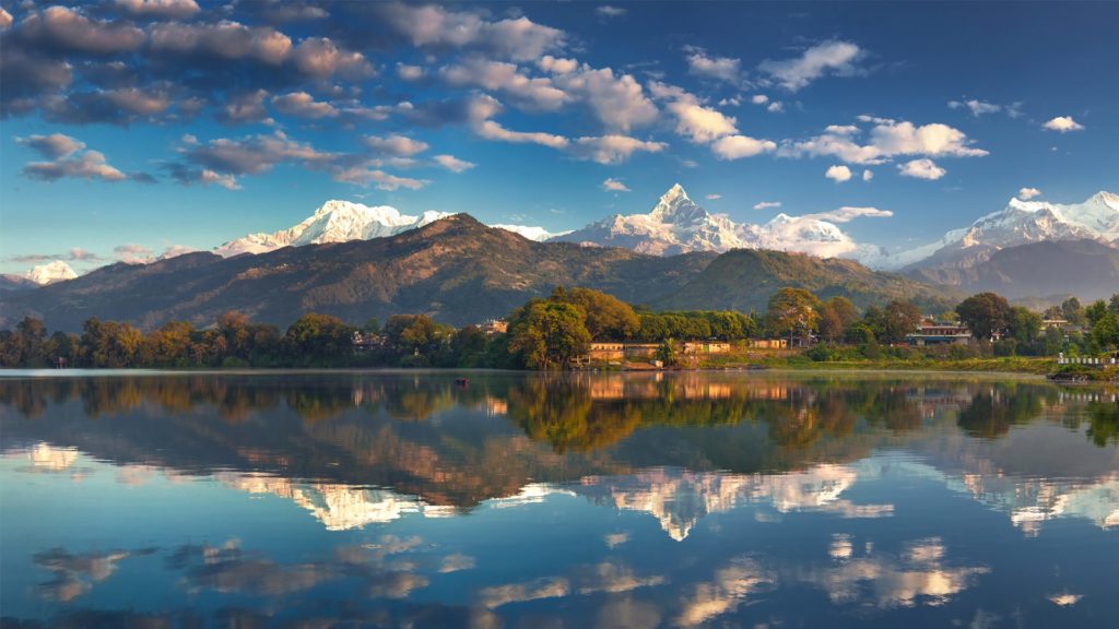
Day 24 – Flight: Jomsom – Pokhara (900m)
Day 25 – Morning Flight: Pokhara – Kathmandu. Overnight hotel.
Day 26 – Final Departure.
Tribhuvan International airport (Google Map)
3 Hours Before Flight Time
Arrive at Kathmandu. Transfer to Hotel.
Full day guided sightseeing around world heritage sites inside the Kathmandu Valley.
Join the welcome dinner with Live Nepalese cultural program hosted by Makalu Adventure. Hotel Overnight.
After breakfast you will board your private transport and start the drive to Dumre. This drive can take up to five hours and packed will be lunch provided. Your adventure vacation truly starts the moment you reach Besishar where your crew will be waiting for you.
Pass through the village of Besisahar and descend to the river valley. Crossing the river the trail climbs steeply and continues contouring in wet subtropical forests and paddy fields. The trail continues north above the Marsyangdi Khola towards Khudi Khola, a major tributary that drains the East End of the Lamjung Himal. Then, crossing suspension bridge to come back to the Marsyangdi Khola you reach the village of Khudi
The changes in the valley’s ecosystem and its physical characteristics become evident now. Himalchuli is the major summit to the east. Crossing the river to its east bank you pass through the village of Bhulbhule and heading north continue past Ngadi (930 m.) to the ridge top settlement of Bahundanda (1311 m.). The name of this village literally means “Brahmin Hill”.
Descend to the valley floor and then, crossing the river, climb steeply out of it to follow a trail beautifully carved out of the rock wall of the valley. Passing through Khani Gaoon and Ghermu you reach Sangye. Continue along the West Bank of the Marsyangdi River through the village of Jagat to Chamje.
A steep trail descends from Bahundanda through green rice terraces before crossing a stream at the bottom of a small waterfall. It then climbs again and traverses the hillside high above the river before reaching the village of Hani Gaon. Ahead, the Marsyangdi valley forms a steep V-shape, and we follow the winding mountain path down through Syange and along the river for some distance. The trail then climbs steeply and the path is cut into the sheer cliff-face some 200-300m above the riverbed. Eventually we descend to the village of Jagat, situated on a shelf which juts into the precipitous Marsyangdi valley, and then climb steeply up through a forest to a wonderful teahouse just before Chamje, marked by a magnificent waterfall on the opposite bank. Chamje is an atmospheric village of traditional style teahouse, always packed with local horses, also bedding down for the night.
Getting right into the spirit of the trek this morning, we begin before the sun hits on a two hour hike – straight up. After descending to the river and crossing a suspension bridge, we begin a steep climb to some small teahouses at Sattale. After chai, we continue on an undulating path above the river, climb the switchbacking path to the top of the hill, and are treated to the sight of Tal below us on a wide plain by the river. Though it is enclosed by cliffs, the level area looks reassuring after the harrowing mountain paths on which we have just traveled. Beyond Tal and the checkpost, the valley narrows and the path becomes high and winding, and in several areas is actually hewn from the rock. Beyond the small village of Karte, there is a bit more exposed trail walking before the path drops again to the river. We cross a suspension bridge, and climb the short distance to the stone kani marking the entrance to Dharapani and another checkpost. As we cut through a narrow field from the village, the Dudh Khola, which originates from the south face of Manaslu, enters on the opposite bank. The Marsyangdi then veers to the left, and as Annapurna II (the 16th highest mountain on the planet) becomes visible ahead, we arrive at Bagarchhap, a Tibetan village with prayer flags fluttering in the breeze.
*** This is where the ‘Remote Nar Phu’ & the ‘Lost Worlds of Manaslu & Nar Phu’ treks meet ***
Continuing to climb through forests of pine and oak, we pass through Danagyu before coming to a thundering waterfall, where we turn left and head up the high trail to Koto. After an hour of lovely, open forests, we reach a clearing at the top of the trail and a charming Tibetan teahouse where we will stop for a break. Pausing for breath, we can look back for views of Manaslu. An hour away is the wonderful Gurung village of Timang, where the villagers might be harvesting their crops of buckwheat or stuffing local sausages. Heading back down to the village of Koto Qupar, our base for the trek up to Nar Phu, we can look straight up at nearby Annapurna II – a stunning sight convincing us that we are deep in the Himalayan mountains! Koto Qupar. The villagers are mostly from Nar and Phu and this is the gateway to their region.
This morning we head out early, as we have a long and somewhat difficult day before us. Just past the checkpost, we cross the river leading to the Nar Phu valleys, and hike up through beautiful woods above the Phu Khola (river). The route takes us through some beautiful woods and past several small shelters (caves) and a pilgrims’ ‘dharmasala’. As we emerge out of a narrow canyon, the trail actually passes under a wide waterfall just before the dharmasala, from which point the woods become thinner and the vistas wider. A stunning start for the Nar Phu trek! We camp at the dharamsala, a lovely campsite.
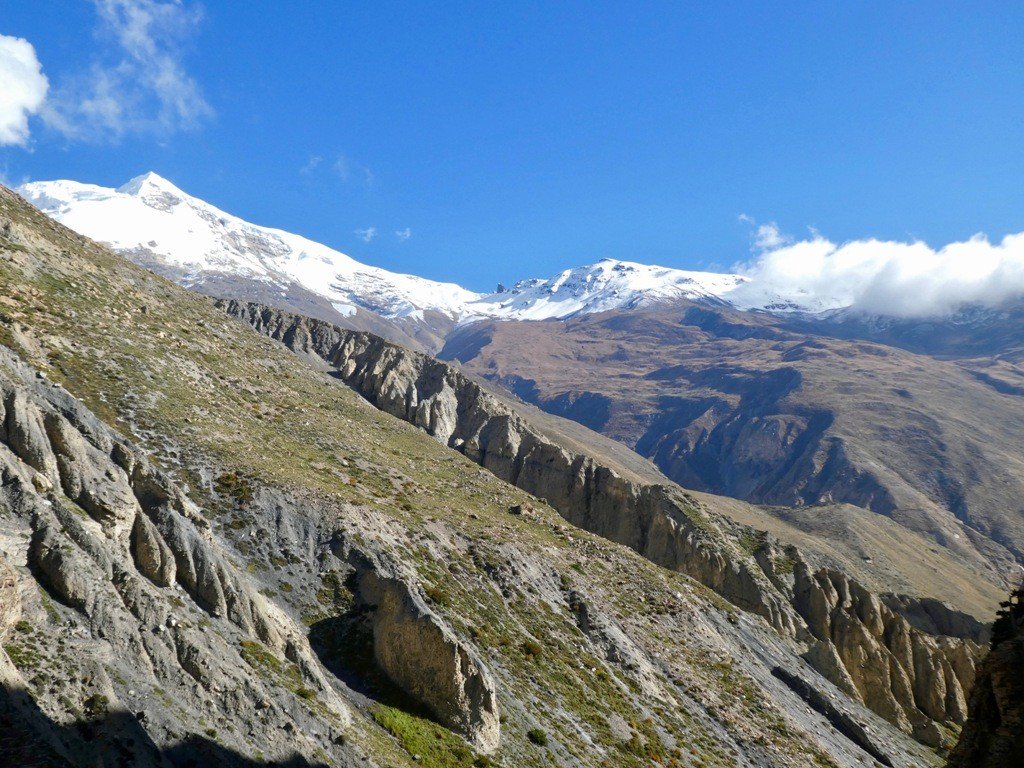
The mountains around us are utterly spectacular, and the Phu Kosi shadows the trail far below. An hour past Meta, Junam is the second semi-permanent settlement, one where “khampas” from Tibet sometimes sheltered. Above the kharka to the right looms a massive glacier, which falls jaggedly down to the high pastures above us. It’s all truly amazing scenery. Across the river, the cliffs contort in swirls and waves, similar to Ladakhi landscapes.
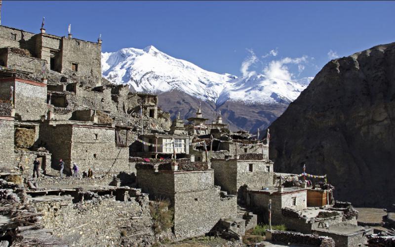
The next semi-permanent settlement is Chako, formerly a Khampa settlement, where grass lies tied in bunches to dry on all the rooftops and prayer flags flutter in the breeze. Last year we saw a massive yak caravan from Phu pass by at Chako on their way down to Manang to re-supply. A scene from old Tibet! Many more ups and downs take us to tonight’s campsite at Kyang, the extensive winter settlement of Phu, on a plateau high above the river.
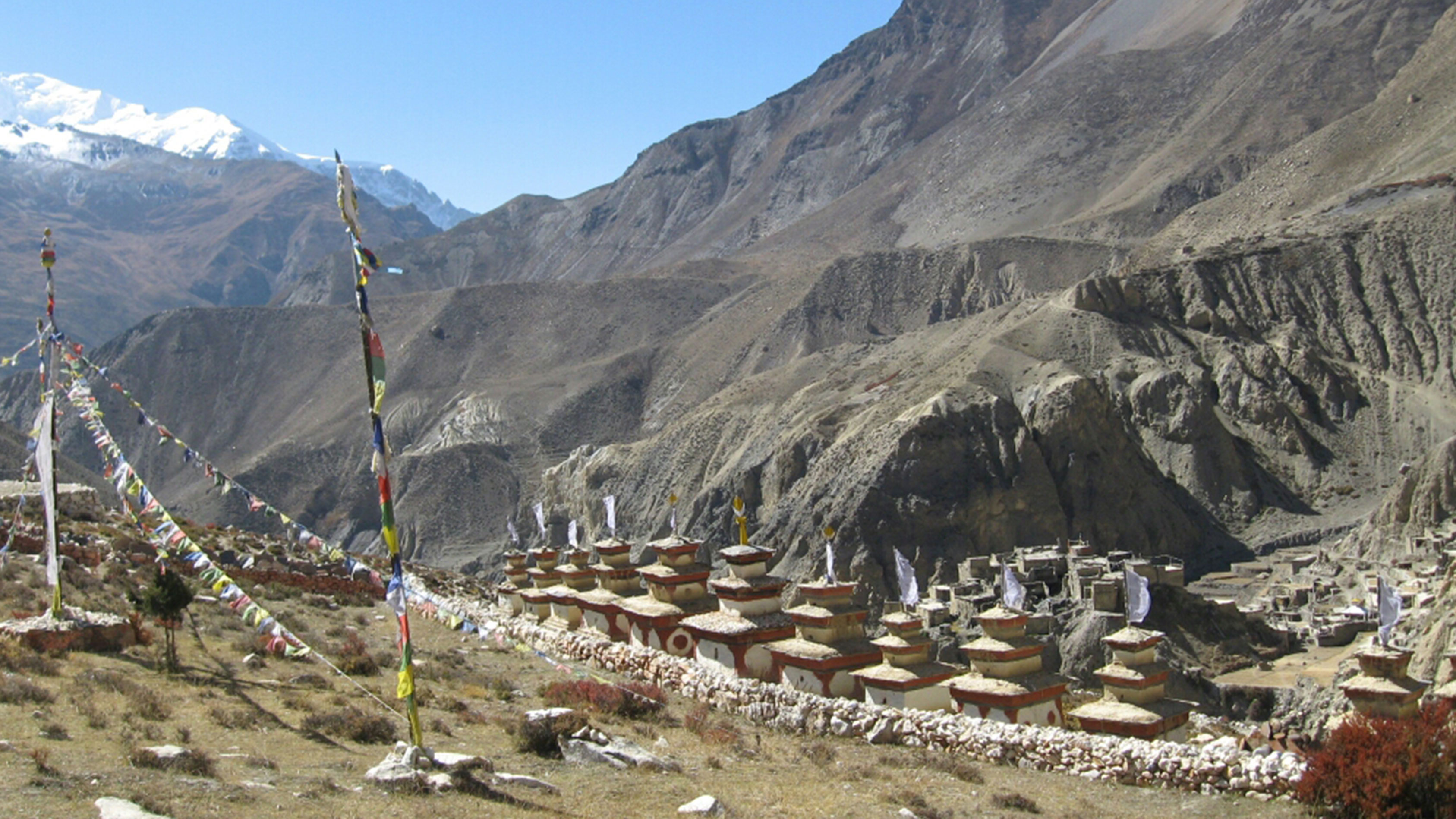
Dropping steeply down to the river, we trek for a while along the river bank and past the “submarine” rock, passing some small possible campsites along the way. Today, we really start to see some of the unique, colorful chortens for which Nar and Phu are justly famous. We have to rock-hop carefully across a small glacial stream before reaching a larger one with a bridge only half covered with large slabs of slate. Some large steps do the trick! Another hour and a half of trekking through scenic canyonlands and gorges, and the “leaning tower of Pisa” monolith guards the steep trail up to the Phu gate, called Pupigyal Kwe. This ancient gate provides us with our first view of the three villages of Phu, as well as an old “dzong” and the remains of two forts, all now in ruins, but impressively situated atop the flatlands before Phu.
Just before the bridge to Phu, a line of wonderful chortens color the landscape and lead the way to the main village of Phu, perched high up on a hill, amphitheater style. We will set up camp on the lower reaches of Phu, formerly called Gomdzong, and head up to the famous Tashi Lhakhang Gompa on a neighboring hillside to pay our respects to Lama Karma Sonam Rimpoche, a “trulku” who came to Nepal with HH the Dalai Lama back in ’59. He is also a renowned “amchi” or Tibetan doctor, as well as a thanka painter and father of several children (some “trukus” as well as certain lamas are permitted to marry). Later, we might head up to the village to hunt down some chang.
Having spent quite a few days getting to Phu, we will spend a few days in the area to enjoy it, meet the local Phu residents and do some exploring up the wide valley systems above us. Tibet is two long days away, so a bit far for a visit, but we might walk up the valley to the summer grazing settlement, or “kharka” at Ngoru, a three hour’s walk past the gompa. Phu itself is an incredibly interesting village, and a day is well spent sitting with the villagers as they spin their yak and sheep wool and chat, pound mustard seeds into a paste for oil, or involve themselves in the countless activities that take up a day in Tibetan villages. For photographers, the light is spectacular, and the skies a deep blue, and we may even see some blue sheep on the surrounding hillsides.
Back through Phu gate, we descend to the river, and retrace our steps back to Junam karka, a lovely spot as any for our campsite for the evening.
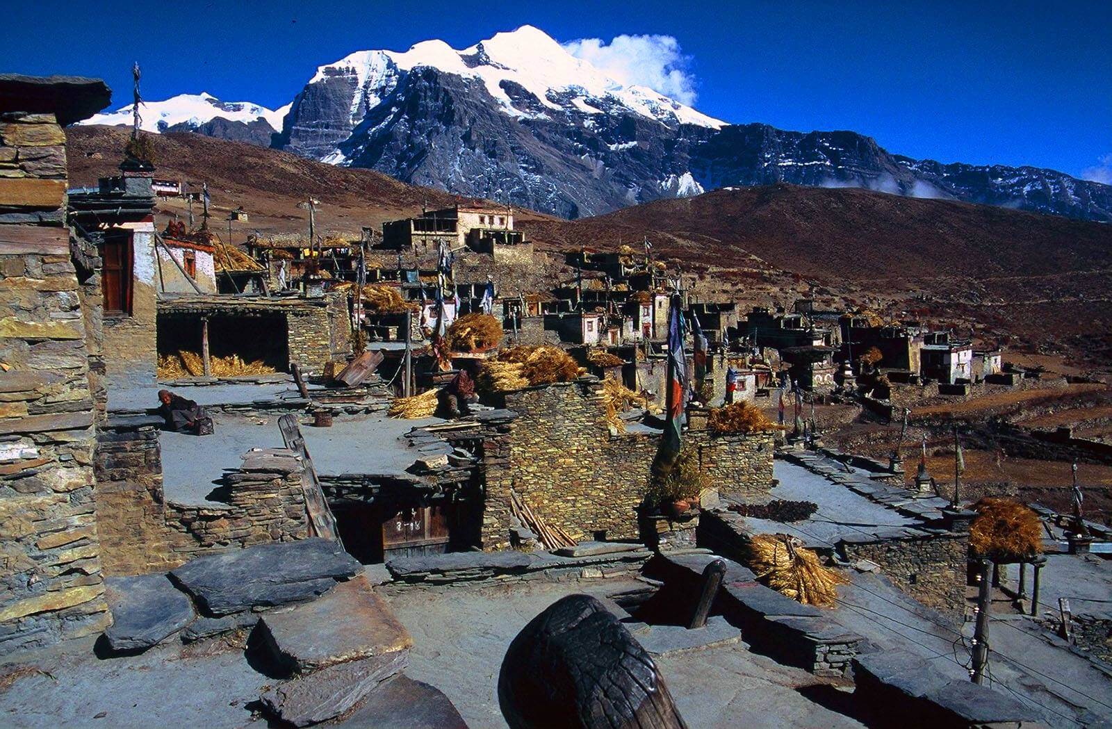
Another classic Himalayan trekking day, as we trek down to the old bridge spanning a deep, contoured and narrow gorge (cameras out for this crossing!), and then all the way back up again. It’s a good thing the scenery is so stunning … Below us sit Gyalbu Kumbu, built in 1650, and Satte gompa, both empty. We finally reach the Nar gates at the top of the hill, and pass by yet another line of wonderfully painted, bamboo-topped chortens and a large tiered chorten before turning the corner and being rewarded with sublime views of Nar, the undulating patterns of the surrounding barley and mustard fields, four old, colorful and traditional gompas and the snow-peaks looming overhead. We arrive early, so will have some lunch in the sun before doing some exploring. And what exploring there is to do…
Physically, Nar is not far from the main Annapurna trail, but it feels centuries away, is rarely visited by trekkers and is about as picturesque as they come. Nar is bit more social and lively than Phu, and the village ‘square’ is full of chatting women with their back-strap looms weaving wool fabric for rugs and blankets, pounding mustard seeds for oil, or spinning the ubiquitous wool while catching up on the news. The children in Nar seem to be always out in the streets, presumably preferring this life to the classroom! Each family in Nar seems to have at least one son or daughter in a gompa, and many live at home or visit frequently, so there is the resonating sound of cymbals, chanting and drums echoing throughout the village. Other Nar villagers may be printing prayer flags, doing some carpentry, collecting wood from the forest and carrying large loads with a head-strap back up to the house, harvesting the crops, tending the yaks, sheep and goats or spinning the prayer wheels in the center of town.
The Kang La is not a difficult pass, but it could be a long day if there is snow on the pass or the altitude is taking it’s toll. The Kang La, at 5240m, is an absolutely spectacular pass looking over Annapurna II, Gangapurna, Tilicho peak, the peaks surrounding Tilicho and the airport at Hongde. The trail down initially is steep, and scree jumping seems to be the easiest option for the descent.
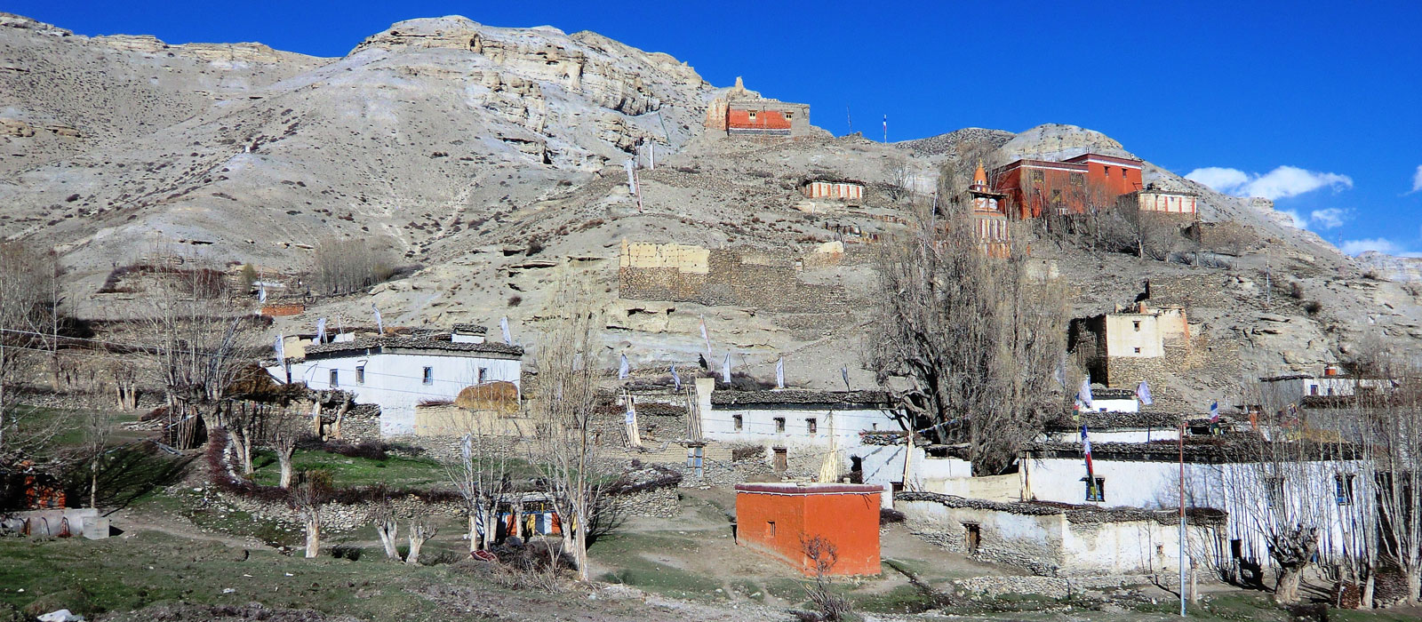
Ngawal, on the upper Pisang route of the Annapurna circuit (off the main Annapurna circuit), can be reached in as little as two hours from the pass, but the walk down is so nice that we will take it easy and enjoy the views. Just before Ngawal is an unusual grouping of chortens and prayer flags, and marks a meditation cave far up in the hills. Ngawal is a wonderful, old village of cobbled streets, prayer wheels and beautiful architecture, obviously a hub of religious activity in previous times.
Leaving Ngawal, we trek southwards along the ‘Upper Pisang’ route, a wonderful trail passing through the isolated village of Ghyaru, 3670m, and upper Pisang, 3300m, with amazing views of the Annapurnas, and descend down to the main Annapurna trail at Pisang. After lunch, we continue through some lovely woods past several small settlements and finally arrive at the atmospheric Chame, the district headquarters of Manang, where we set up camp for the evening. Chame is a virtual ‘city’ in the Manang region and a good place to re-fortify!
From Chame the trail condition changes, somewhat. The contnuing trail is not as well maintained as the one up to Chame. Pass through pine forests, over fairly level ground, through the village of Taleku to Bhratang. Like all vilages since Dharapani these predominantly Buddhist villages have an entrance chorten and an exit chorten. Annapurna II can be seen to the south and you are now behind the main Himalaya peaks in their rainshadow area. After crossing a series of woodden cantilever bridges you enter a spruce and fir forest that eventually gives way to a pine forest. After days in the gorge the forests provide a welcome change. Crossing the river to its left bank you reach your lodge at the village of Pisang. You may want to visit the village before dinner.
You are now in the dry arid region of Manang called Nyesyang. Since this area falls in the rainshadow area of the Himalaya it seldom rains in the summer months, though it snows in the winter and the snow remainas on the gorund for a long time. The population is mostly farmers and traders though it is the men that do most of the trading. People in this area keep comparatively less domestic animals and the consumption of meat is very limited.
There are two routes leading leading out of Pisang towards the Manang valley. The one you will follow stays to valley floor, on the left bank. Spectacular views of Annapurna III and IV along with Gangapuran and Tilicho peaks abound. This is possibly the best day for viewing mountains. You will pass through the village of Hongde where there is a STOL airfield servicing the Manang district.
Muktinath is a sacred pilgrimage site to both Hindus and Buddhists who flock there annually for their respective festivals. A rest day here allows you the opportunity to explore the area and the ancient shrines. Of particular interest is the temple of the Hindu God Vishnu and the one hundred and eight waterspouts where devotees bathe. From Muktinath there are beautiful views of Mt. Dhaulagiri (8167 m.)
Half an hour away from Braga, upstream and after a slight climb is the village of Manang, which lends its name to the whole district upward of Chame. Manang has a few shops where one can re-stock on supplies like chocolates, films and alkaline batteries – all, of course, for a price. Past Manang, the trail climbs steeply to the village of Tenki, which is the last permanent settlement, this side of the Thorung La. Climb a little further and then contour slowly past pastures to Yak Kharka (literally meaning Yak Pastures) to lodge at Letdar
Continue through pastures, which eventually give way to high arid desert at Phedi, at the base of Thorung La.
Leaving the river valley you set out early in the morning provided the weather is good and it is not snowing. From Phedi ascend to a notch and turning left head for the Thorung La. A chain of rocks marks the pass, which might not be visible if there is snow. Beyond the pass you enter the river valley of the Kali Gandaki River. The descent from the pass to Muktinath is steep but not difficult.
Trek down along a level but rocky trail through juniper thickets to Jomsom. In the late afternoon it gets very windy and there is likelihood of getting small pebbles in the wind. Take care to guard your eyes and cover as much of your skin surface as possible. Your sunglasses should, preferably, have plastic lenses.
Take your flight back to Pokhara. Enjoy the attractions of Pokhara yourself freely. Overnight Hotel.
Take a flight to Kathmandu (1/2 hour). Enjoy the rest of time exploring and enjoying in Kathmandu.