+977 61 454404
gofortrekking@gmail.com

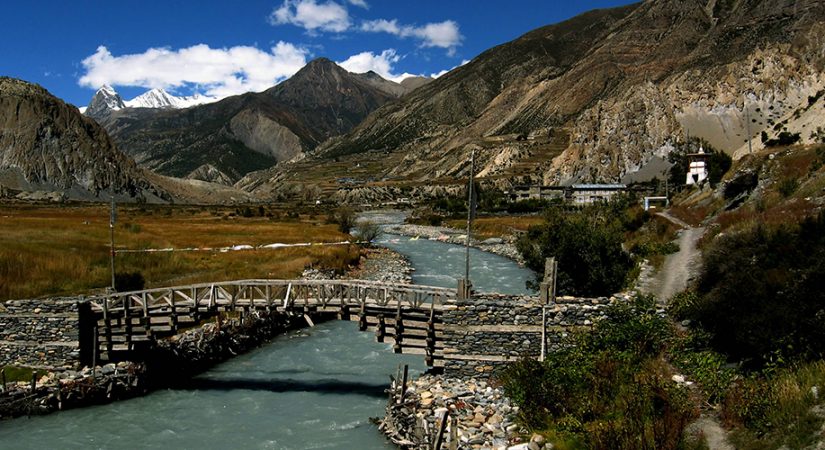
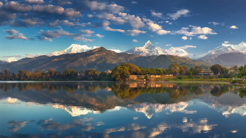
Jomsom Spreads Over The Banks Of Kali Gandaki River. The Towering Peaks Of Dhaulagiri And Nilgiri Form An Attractive Backdrop. Being District Headquarter, It Is Primarily An Administrative And Commercial Center With Government Officials And Merchants Rubbing Shoulders With The Local Inhabitants Of The Region, Known As Thakalis. A Company Of The Nepalese Army Is Stationed Here. Nearby Is An Airfield, From Where Flights Operate Regularly. However, Due To The Strong Winds That Buffet The Area In The Afternoons, The Airfield Is Functional Only In The Forenoon.views From Jomsom Are Enchanting As The Nilgiri (7061m) And Dhaulagiri (8167m) Ranges Reflect The Golden Rays Of The Rising And The Setting Sun. The Entire Panorama Is Filled With A Golden, Glittering Light, Which Forms A Dramatic Contrast.
Life Here Is A Balance Of Hard Work And Ancient Culture. Many Visitors Find Their Most Lasting Impression Of Nepal Comes Not From The Ancient Temples In The Urban Valleys But From Visits To Places Like Jomsom And Its Exhilarating Spiritual Environment. Jomsom Area Is Not Only The Most Popular Trekking Destination In Nepal But Also The Gateway To Upper Mustang Within The Hindu Kingdom Of Nepal.The Ancient Trade Route To Mustang And Tibet, up The Kali Ghandaki River, Presents One Of The Most Developed Trekking Trails Offering Comfortable Lodges Run By Gurung And Thakali Families. Starting From Pokhara We Ascend The Annapurna Foothills Through Picturesque Gurung Villages And Continue Through Lichen-draped Rhododendron Forest To Climb Poon Hill At Dawn For Spectacular Views Of Dhaulagiri And Annapurna Ranges. Later We Will Trek Up The Deepest Valley In The World Situated Between Two Himalayan Giants, Dhaulagiri I (8,167m) And Annapurna I (8,091m). As We Trek Up The Kali Gandaki Valley We Pass Though The Traditional And Prosperous Villages Of Tukuche, Ghasa, Marpha And Jomsom.
Outline Itinerary:
Day 01: Pokhara flight to Jomsom & trek to Kagbeni (2800m) (4 & half hours)
Day 02: Kagbeni trek to Muktinath (3800m) (4 hours walk)
Day 03: Muktinath trek to Marpha (2670m) (6 hours walk)
Day 04: Marpha trek to Ghasa (2010m) (6 hours walk)
Day 05: Ghasa trek to Tatopani (1200m) (5 hours Walk)
Day 06:Tatopani trek to Ghorepani (2870m) (7 hours walk)
Day 07: Visit Poon hill & trek to Tadapani (2590m) (5 & half, hours walk)
Day 08: Tadapani trek to Ghandruk (1950m) (3 and half, hours walk)
Day 09: Ghandruk Trek to Pothana (1990m) (6 hours walk)
Day 10: Pothana trek to Dhampus Phedi & drive Pokhara (820m) (5 hours)
Day 11: Pokhara to Kathmandu
Tribhuvan International airport (Google Map)
3 Hours Before Flight Time
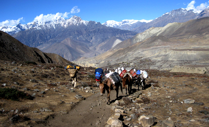
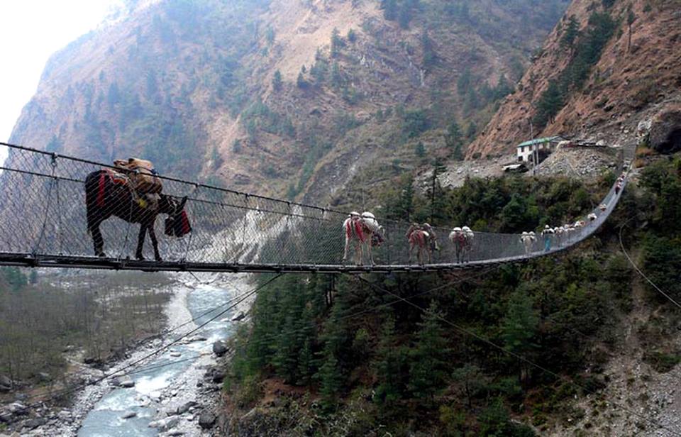
Fly from Pokhara to Jomsom (2700m.) and it takes about 25 minutes and trek from Jomsom to Kagbeni (2800m.) which takes about four hours. You take the early morning flight which again will give close-up views of the Annapurna range, Dhaulagiri and nearby satellites, 20 minutes flight in a small aircraft. Directly north of Jomsom is the pretty village of Kagbeni, There are about 80 families living here, most of them traders who are the link in the chain between modern Nepal and the Tibetan-type people of Mustang. Just out of Jomsom you cross a small hanging bridge and then walk along the banks of the Kali Gandaki. The trail is quite barren with craggy rocks and sand and is mostly flat, which makes it very easy going. This very easy, enjoyable start is at the same time picturesque, with views of big peaks all around such as Dhaulagiri (26,794ft), Tukuche (22,703ft) and in the west the awesome mountain above Kagbeni, Nilgiri (22,769ft). Over to the south and south-west can be seen the entire Annapurna Massif. You are more than likely to meet Indian pilgrims on their way to and from Muktinath on this stretch, and other Europeans for an hour or two who will be on the world-famous Annapurna Circuit. Upon reaching Kagbeni there is a taste of scenes to come in Upper Mustang, what with its narrow alleyways and tunnels, irrigation canals, green fields of wheat and barley and a large red gompa. At the police check-post at the north end of the village there is a sign saying ‘Restricted area, tourists please do not go beyond this point.
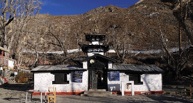
Trek from Kagbeni to Muktinath (3800m.) which takes about 4 hours. The Trail steeply ascends for couple of hundred Meters. While gradually walking you can enjoy beautiful deserted landscape, Caves, old Tibetan Style Villages, apple Garden, Yaks Herds, Sheep Herds and so on. You can look at Thorong La valley straight up to the Muktinath. You can enjoy delicious lunch at Jharkot and visit Monastery believed to be built in 15 century. Now you head towards Muktinath following steep ascent path for half an hour. You stay overnight at Muktinath village. From here you hike to Rani Pauwa (3700m.), an important pilgrimage site for both Hindus and Buddhists. Here you come across Natural flaming which really exhilarates you. At this point, you can see splendid view of Dhaulagiri (8165m), Nilgiri (7061m.) and others. Now you walk for fifteen minutes to reach Muktinath Temple, where you can enjoy a holy bath of 108 Taps. The people of Kagbeni, Jharkot and Muktinath are close to the life style, culture, religion and idea of Tibetan people.
Muktinath trek to Marpha (2670m) (6 hours walk)Trek from Muktinath to Marpha (2670m.) and it takes about approximately six hours. You now begin the descent down the dramatic Kali Gandaki Gorge, initially through arid country in the same geographical and climatic zone as Tibet. After passing through Jharkot and Khingar, villages with typical Tibetan architecture, you follow the valley floor most of the way to Jomsom. Jomsom is sprawled along both banks of the Kali Gandaki and from here there are fine views of the Nilgiri peaks. You continue down to Marpha, a delightful Thakali village, complete with a drainage system beneath the flagstone streets. Its narrow alleys and passageways provide welcome shelter from the strong winds of the Kali Gandaki Gorge and Marpha is particularly well known for its apples, apple cider and apple brandy, apricot and peach rakshi (Nepali wine).
Marpha trek to Ghasa (2010m) (6 hours walkTrek to Ghasa (2010 meters) 6 hours. We descend through the valley following the Kali Gandaki River to Ghasa. We walk along the bank of Kali Gandaki River. Ghasa is small town near the Kaligandaki River and popular for the bird Watching. The trail from Marpha to Ghasa taken as the deepest gorge in the world. Because the mountain Annapurna I 8091m and Dhaulagiri 8168 m. high on both Sides of the River making deep valley. The trail is interesting from Marpha to Ghasa because you pass the beautiful village Tukuche, Kobang, Larjung, Kokhethanti and Kalopani/Lete then you arrives in Ghasa.
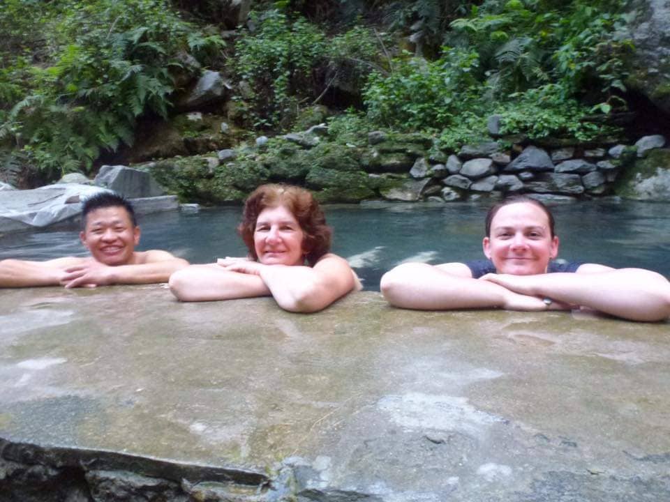
Ghasa trek to Tatopani (1200m) (5 hours Walk)Trek from Ghasa to Tatopani (1200m.) which takes about five hours. The trail descends steeply up to Rukse Chhahara (Rukse Waterfall) which is amazing to look at. There is situated the deepest gorge of the world between two mountains Annapurna I (8091m.) and Dhaulagiri I (8167m.) facing each other near Rukse Waterfall. Now the trail ascends slightly to Tatopani through different human settlements. You can enjoy the hot spring at Tatopani as the word Tatopani is termed after the natural hot spring situated at the bank of the Kali Gandaki River. It is popularly believed that taking bath in Hot Spring helps to solve rid of skin diseases. Along this, it gives you physical and mental refreshment as well.
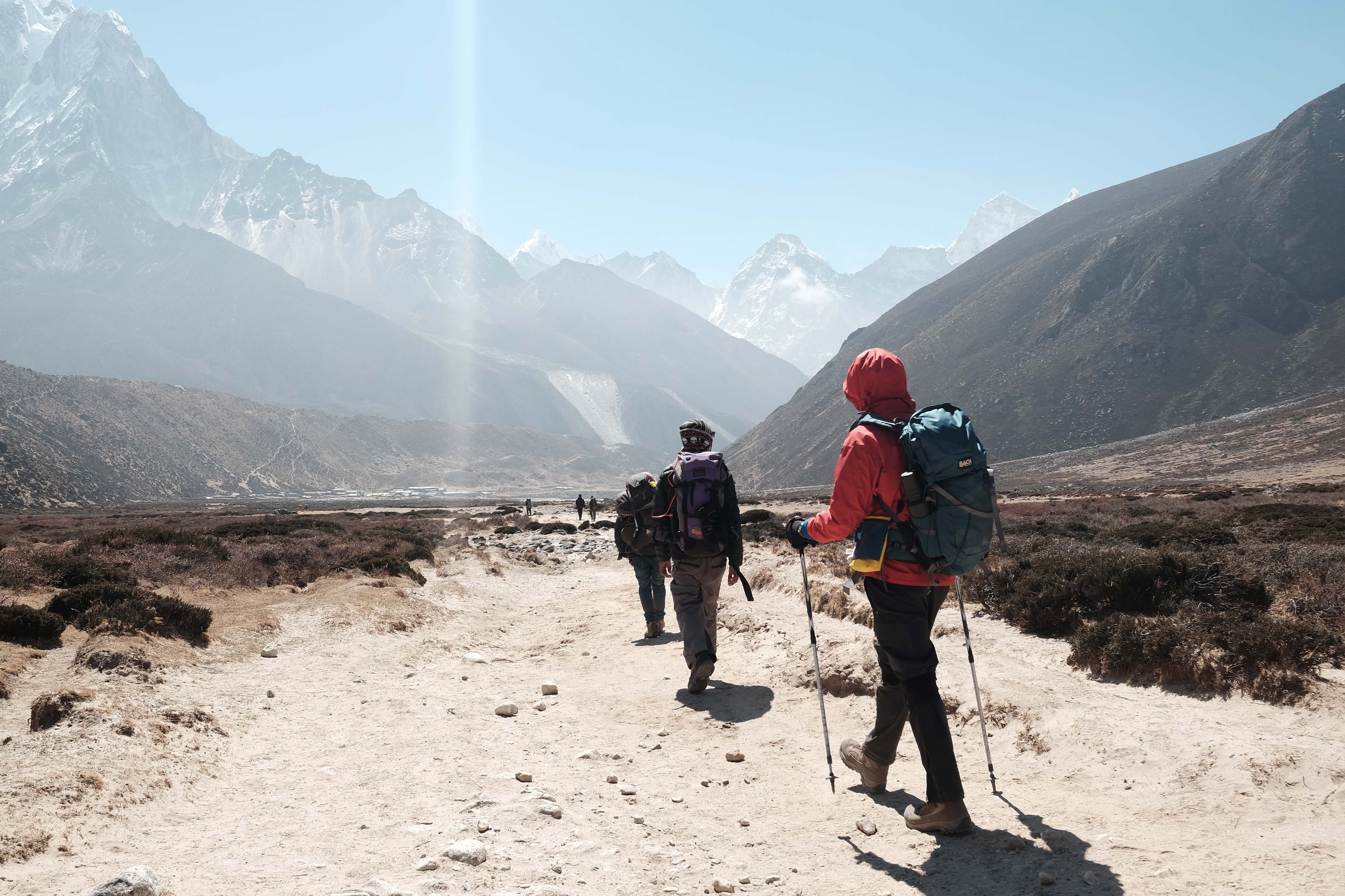
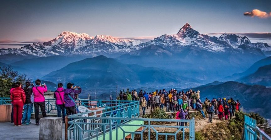
Trek from Tatopani to Ghorepani (2853m.) and it takes about seven hours. Your trail passes through flat level of the land at some distance. Then the trail begins ascending steeply for at least one hour. Now path goes up through different villages inhabited by the people of different caste and agricultural land. The majority of the people here serve Gorkha Regiment and Indian Regiment as well. While trekking you cross through the Kali Gandaki River with panoramic view of Dhaulagiri and Annapurna ranges. Now the trail ascends gently all the way to Ghorepani passing through small villages like Phalate, Chitre and so on. While trekking you pass through rhododendron forests and come across the wild life such as monkeys and birds of various species. You are accompanied by more panoramic views of different mountains. Ghorepani (Watering to Horse) is a small pass and the village of Deorali. Although there is time enough to continue, it is better to stay here overnight so that we can make the morning trip to Poon Hill (3180m.) for an outstanding panorama of Dhaulagiri I, II, III, IV, Tukuche peak, Dhampus peak, Nilgiri ranges, Annapurna I, Baraha Sikhar (Twelve peaks or renowned as French Fang),Annapurna South, Himchuli, Fishtail and Mardi Himal. The view you can see from here is probably the best view in the world. Not only this, Poon Hill is crowded by different visitors to enjoy the sunrise and sunset over the snow-capped mountain.
Trek from Tatopani to Ghorepani (2853m.) and it takes about seven hours. Your trail passes through flat level of the land at some distance. Then the trail begins ascending steeply for at least one hour. Now path goes up through different villages inhabited by the people of different caste and agricultural land. The majority of the people here serve Gorkha Regiment and Indian Regiment as well. While trekking you cross through the Kali Gandaki River with panoramic view of Dhaulagiri and Annapurna ranges. Now the trail ascends gently all the way to Ghorepani passing through small villages like Phalate, Chitre and so on. While trekking you pass through rhododendron forests and come across the wild life such as monkeys and birds of various species. You are accompanied by more panoramic views of different mountains. Ghorepani (Watering to Horse) is a small pass and the village of Deorali. Although there is time enough to continue, it is better to stay here overnight so that we can make the morning trip to Poon Hill (3180m.) for an outstanding panorama of Dhaulagiri I, II, III, IV, Tukuche peak, Dhampus peak, Nilgiri ranges, Annapurna I, Baraha Sikhar (Twelve peaks or renowned as French Fang),Annapurna South, Himchuli, Fishtail and Mardi Himal. The view you can see from here is probably the best view in the world. Not only this, Poon Hill is crowded by different visitors to enjoy the sunrise and sunset over the snow-capped mountain.
Trek from Ghorepani to Poon Hill (3210m.) to Tadapani (2675m.) which takes about 5 and half hours. Early morning trip to Poon Hill (3210m.) to enjoy the sunrise view over Mt. Dhaulagiri (8167m.), Tukuche Peak (6920m.), Nilgiri (6940m.), baraha Shikhar (7847m.), Mt. Annapurna I (8091m.), Annapurna South (7219m.), Annapurna III (7855m.), Machhapuchhare (6993m.), Annapurna IV (7525m.), Annapurna II (7937m.), Lamjung Himal (6931m.) and other numerous snowcapped mountain peaks. After breakfast trek Ghorepani to Tadapani (2590m.). After walking for almost one and half hour you reach Gurung Hill which has the splendid mountain views as Poon Hill. From here you follow small forests with rhododendron, bamboos until you reach Deurali. The trail goes steeply down through deep forests all the way to Banthati. It takes one hour from here to reach Tadapanil After breakfast trek from Ghorepani to Tadapani through the deep forests of rhododendrons, bamboos and oaks. En route, you frequently see waterfalls, rocks, wild animals, local birds and green scenarios. Tadapani is a small village surrounded by beautiful forests which grants you a magnificent view of Annapurna South, Hiunchuli, Fishtail, Annapurna II and so on.
Trek from Ghorepani to Poon Hill (3210m.) to Tadapani (2675m.) which takes about 5 and half hours. Early morning trip to Poon Hill (3210m.) to enjoy the sunrise view over Mt. Dhaulagiri (8167m.), Tukuche Peak (6920m.), Nilgiri (6940m.), baraha Shikhar (7847m.), Mt. Annapurna I (8091m.), Annapurna South (7219m.), Annapurna III (7855m.), Machhapuchhare (6993m.), Annapurna IV (7525m.), Annapurna II (7937m.), Lamjung Himal (6931m.) and other numerous snowcapped mountain peaks. After breakfast trek Ghorepani to Tadapani (2590m.). After walking for almost one and half hour you reach Gurung Hill which has the splendid mountain views as Poon Hill. From here you follow small forests with rhododendron, bamboos until you reach Deurali. The trail goes steeply down through deep forests all the way to Banthati. It takes one hour from here to reach Tadapanil After breakfast trek from Ghorepani to Tadapani through the deep forests of rhododendrons, bamboos and oaks. En route, you frequently see waterfalls, rocks, wild animals, local birds and green scenarios. Tadapani is a small village surrounded by beautiful forests which grants you a magnificent view of Annapurna South, Hiunchuli, Fishtail, Annapurna II and so on.
Trek from Tadapani to Ghandruk (1950m.) and it takes about three & half hours. It is very easy trek by descending gently all the way through rhododendron, oak and other kinds of dense forests. You could hear different kinds of birds chirping on the way. This is one of the popular destinations for the birds’ lovers. Ghandruk is a big Gurung village. There is a handicraft centre and Gurung museum. From this village you could see good views of Annapurna South, Hiunchuli, Gangapurna (7455m.), Annapurna III (7755m.) and Fishtail when you are in Ghandruk please do not for get to visit Gurung museum.
Trek from Ghandruk (1950m.) to Pothana (1990m.) which takes about six hours. First part of your trek is steeply down following stone staircase to Kimbu (Bee hive). Kimbu or Bee hive is located at the elevation of 1200 meters on the bank of Modi Khola. Now your trail steeply ascends following the stone staircase up to Landruk. The trail ascends gently for early two hours and again ascends steeply for an hour to Deurali (2150m.) passing through Tolkha village (1850m.). From this point you can see panoramic view of Dhaulagiri I (8167m.), Annapurna South 219m.), Hiunchuli (6441m.), Fishtail (6997m.), Annapurna III (7755m.), Annapurna IV (7525m.), Annapurna II (7937m.) and Lamjung Himal (6930m.). Now the rest of the trail descends gently down to Dhampus passing through Pothana village (1900m.).
Trek from Pothana to Dhampus Phedi and it takes approximately four hours and drive from Dhampus Phedi to Pokhara drive by taxi it takes 45 minutes. The trail is gently descent up to Dhampus, a village mainly inhabited by Gurung. Now you trek through flat land for some distance and steeply descend to Dhampus Phedi also called surkhet phedi it highway for Beni and Baglung.
Flight or by Bus to Kathamndu.